


Anchor Alarm - SailGrib AA
คำอธิบายของAnchor Alarm - SailGrib AA
Anchor Alarm โดย SailGrib เป็นแอพปลุกสมอที่มีคุณสมบัติครบถ้วนที่ทันสมัย
- เริ่มแอพก่อนจุดยึดของคุณแอพจะบันทึกและวาดเส้นทางของคุณบนแผนที่
- วางโทรศัพท์ของคุณไว้บนตารางชาร์ต
- มัวร์โดยไม่ต้องกังวลกับแอปพลิเคชัน
- กลับไปที่แอปพลิเคชันบนแทร็กค้นหาจุดที่ตรงกับตำแหน่งของเรือในเวลาที่จอด คุณควรจะตรวจจับได้ค่อนข้างง่ายบนแผนที่เนื่องจากการเคลื่อนที่ย้อนกลับหลังจากการทอดสมอ
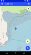
- จัดกึ่งกลางแผนที่บนจุดยึดโดยใช้เครื่องหมายเป้าหมายที่อยู่ตรงกลางของหน้าจอ
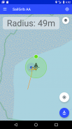
- กดปุ่ม "Anchor" สีน้ำเงินเพื่อกำหนดตำแหน่งจุดยึด
- ปรับรัศมีของพื้นที่เปียกโดยเลื่อนจุดสีเขียวไปที่ขอบของโซน
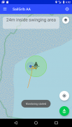
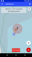
- แก้ไขพื้นที่เปียกโดยกดปุ่ม "Anchor" อีกครั้งจะเปลี่ยนเป็นสีเขียว นาฬิกาปลุกถูกเปิดใช้งาน
ใหม่: ใช้แผนภูมิการพายเรือ Navionics ของคุณภายในแอป!
ด้วยตัวเลือกพรีเมียม:
- กำหนดโซนเปียกหกเหลี่ยมและแก้ไขได้บนหน้าจอ
- ส่งอีเมลเมื่อมีการปลุก
- ดูแผนที่ SailGrib WR
- นำเข้าร่องรอย GPX ของ SailGrib WR หากคุณลืมเริ่มแอปพลิเคชันก่อนที่จะเปียก
แอปทำงานในพื้นหลังและใช้เทคนิคล่าสุดของ Android เพื่อลดการใช้พลังงานในขณะที่เพิ่มความแม่นยำของตำแหน่ง
โปรดทราบว่าความแม่นยำของตำแหน่งของคุณขึ้นอยู่กับโทรศัพท์และตำแหน่งของคุณ ในเดือนมีนาคม 2564 เราพิจารณาว่าโทรศัพท์ส่วนใหญ่มีความแม่นยำระหว่าง 2 ถึง 10 เมตรขณะอยู่ในทะเล
Anchor Alarm - SailGrib AA--เวอร์ชั่น3.2
(06-10-2023)Anchor Alarm - SailGrib AA - ข้อมูล APK
เวอร์ชั่น APK: 3.2แพ็คเกจ: com.sailgrib.anchoralarmเวอร์ชั่นล่าสุดของAnchor Alarm - SailGrib AA
เวอร์ชั่นอื่น


แอปในประเภทเดียวกัน

คุณอาจจะชอบ...


